


Your one stop site on everything Victoria Falls - Mosi Oa Tunya!
"One of the seven wonders of the world - a UNESCO World Heritage site"

VisitVicFalls
Weather and Climate

|
|
||||||||||||||
|---|---|---|---|---|---|---|---|---|---|---|---|---|---|---|---|
|
|
|
||||||||||||||
|
|
|
||||||||||||||
|
Köppen Classification: Mid-Latitude Steppe and Desert Climate |
|
||||||||||||||
|
|
|
||||||||||||||
|
|
|
||||||||||||||
|
|
|


Victoria Falls - Minimum & Maximum Temperatures °C
Victoria Falls - Average Rainfall in mm

Victoria Falls - Average Temperatures °C

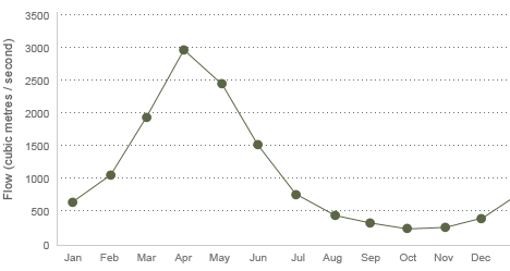
Victoria Falls Flow
(Cubic Metres / Second)
Victoria Falls - Livingstone and Surrounding Areas Topography

Climate Classification
The Victoria Falls - Livingtstone Köppen Climate Classification is Mid-Latitude Steppe and Desert Climate. This climate type is characterized by extremely variable temperature conditions, with annual means decreasing and annual ranges increasing poleward, and relatively little precipitation. This climate is typically located deep within the interiors of continents and is contiguous with the tropical desert climates of North and South America and of central Asia. This region type owes its origins to locations deep within continental interiors, far from the windward coasts and sources of moist, maritime air. Remoteness from sources of water vapor is enhanced in some regions by mountain barriers upwind. The Köppen Climate Classification subtype for this climate is "Bsh". (Mid-Latitude Steppe and Desert Climate).
The average temperature for the year in Victoria Falls is 70.5°F (21.4°C). The warmest month, on average, is November with an average temperature of 77.5°F (25.3°C). The coolest month on average is July, with an average temperature of 59.4°F (15.2°C).
The average amount of precipitation for the year in Victoria Falls is 25.9" (657.9 mm). The month with the most precipitation on average is December with 6.8" (172.7 mm) of precipitation. The month with the least precipitation on average is June with an average of 0.0" (0 mm). In terms of liquid precipitation, there are an average of 60.0 days of rain, with the most rain occurring in January with 14.0 days of rain, and the least rain occurring in June with 0.0 days of rain.
Vegetation
Mopane woodland savannah predominates in the area, with smaller areas of Miombo and Rhodesian Teak woodland and scrubland savannah. Riverine forest with palm trees lines the banks and islands above the falls. The most notable aspect of the area's vegetation though is the rainforest nurtured by the spray from the falls, containing plants rare for the area such as pod mahogany, ebony, ivory palm, wild date palm and a number of creepers and lianas.Vegetation has suffered in recent droughts, and so have the animals that depend on it, particularly antelope.
Wildlife
The national parks contain abundant wildlife including sizable populations of elephant, buffalo, giraffe, zebra, and a variety of antelope. Lion and leopard are only occasionally seen.Vervet monkeys and baboons are common. The river above the falls contains large populations of hippopotamus and crocodile. Elephants cross the river in the dry season at particular crossing points.
Klipspringers and clawless otters can be glimpsed in the gorges, but they are mainly known for 35 species of raptors. The Taita Falcon, Black Eagle, Peregrine Falcon and Augur Buzzard breed there. Above the falls, herons, Fish Eagles and numerous kinds of waterfowl are common.
Fish
The river is home to 39 species of fish below the falls and 89 species above it. This illustrates the effectiveness of the falls as a dividing barrier between the upper and lower Zambezi.
Zimbabwe - Average Temperature in F°

Victoria Falls - Average Humidity


Natural environment
National parks
The two national parks at the falls are relatively small—Mosi-oa-Tunya National Park is 66 square kilometres (16,309 acres) and Victoria Falls National Park is 23 square kilometres (5,683 acres). However, next to the latter on the southern bank is the Zambezi National Park, extending 40 kilometres (25 mi) west along the river. Animals can move between the two Zimbabwean parks and can also reachMatetsi Safari Area, Kazuma Pan National Park and Hwange National Park to the south.On the Zambian side, fences and the outskirts of Livingstone tend to confine most animals to the Mosi-oa-Tunya National Park. In addition fences put up by lodges in response to crime restrict animal movement.In 2004 a separate group of police called the Tourism Police was started. They are commonly seen around the main tourist areas, and can be identified by their uniforms with yellow reflective bibs.'