


Your one stop site on everything Victoria Falls - Mosi Oa Tunya!
"One of the seven wonders of the world - a UNESCO World Heritage site"

VisitVicFalls
Mosi Oa Tunya - Victoria Falls

-
The principal gorges are:
-
First Gorge: the one the river falls into at Victoria Falls
-
Second Gorge: (spanned by the Victoria Falls Bridge), 250 m south of falls, 2.15 km long (270 yd south, 2350 yd long)
-
Third Gorge: 600 m south, 1.95 km long (650 yd south, 2100 yd long), containing the Victoria Falls Power Station.
-
Fourth Gorge: 1.15 km south, 2.25 km long (1256 yd south, 2460 yd long)
-
Fifth Gorge: 2.55 km south, 3.2 km long (1.5 mi south, 2 mi (3.2 km) long)
-
Songwe Gorge: 5.3 km south, 3.3 km long, (3.3 mi south, 2 mi (3.2 km) long) named after the small Songwe River coming from the north-east, and the deepest at 140 m (460 ft), the level of the river in them varies by up to 20 meters (65 ft) between wet and dry seasons.
Satellite image showing the broad Zambezi falling into the narrow cleft and subsequent series of zigzagging gorges (top of picture is north).
Naming:
David Livingstone, the Scottish missionary and explorer, is believed to have been the first European to view Victoria Falls on 16 November 1855 from what is now known as Livingstone Island, one of two land masses in the middle of the river, immediately upstream from the falls on the Zambian side. Livingstone named his discovery in honour of Queen Victoria, but the indigenous name, Mosi-oa-Tunya—"the smoke that thunders"—continues in common usage as well. The nearby national park in Zambia, for example, is named Mosi-oa-Tunya, whereas the national park and town on the Zimbabwean shore are both named Victoria Falls. The World Heritage List officially recognizes both names.
In the fourteen years that followed his "discovery" of the Victoria Falls, Livingstone endured life-threatening hardships in the course of his exploration, including an altercation with a lion that hampered the use of one of his arms. Livingstone’s lack of contact with the outside world over a period of four years raised concerns for his welfare and prompted the New York Herald to send Henry Stanley to find him.
Stanley achieved his goal on November 10, 1871 approaching the explorer in an African village with the immortal words "Dr. Livingstone I presume".
The two struck up a friendship which was only ended when Stanley returned to England in 1872, having failed to persuade the intrepid missionary to accompany him. Dr David Livingstone died on 1 May 1873 at age 60. He had travelled some 50 000 kilometres in Africa, making a considerable contribution to the least known portion of the planet and in so doing became one of the legendary figures of Southern and Central Africa.
David Livingstone gazing upon the Falls, in bronze, from the Zambian shore and Victoria Falls late 19th or early 20th century photograph.
Victoria Falls Bridge initiates tourism:
European settlement of the Victoria Falls area started around 1900 in response to the desire of Cecil Rhodes' British South Africa Company for mineral rights and imperial rule north of the Zambezi, and the exploitation of other natural resources such as timber forests north-east of the falls, and ivory and animal skins. Before 1905, the river was crossed above the falls at the Old Drift, by dugout canoe or a barge towed across with a steel cable.[10] Rhodes' vision of a Cape-Cairo railway drove plans for the first bridge across the Zambezi and he insisted it be built where the spray from the falls would fall on passing trains, so the site at the Second Gorge was chosen. See the main article Victoria Falls Bridge for details.[9] From 1905 the railway offered accessible travel to whites from as far as the Cape in the south and from 1909, as far as the Belgian Congo in the north. In 1904 the Victoria Falls Hotel was opened to accommodate visitors arriving on the new railway. The falls became an increasingly popular attraction during British colonial rule of Northern Rhodesia (Zambia) and Southern Rhodesia (Zimbabwe), with the town of Victoria Falls becoming the main tourist centre.
The Victoria Falls Bridge was built in 1905 to link what are now Zimbabwe and Zambia. The bridge was the vision of Cecil John Rhodes who wanted - perhaps somewhat impractically - the “spray of the Falls on the train carriages”. Unfortunately he died before the bridge was completed and did not visit the famous bridge. The bridge was designed by Sir Ralph Freeman who also designed the Sydney Harbour Bridge.
Constructed from steel, the arch spans 156.50 metres, with a height of 128 metres above the Falls valley floor. Like Sydney, the bridge carries cars, trains and foot traffic and hosts the world-famous, 111 metre Shearwater Bungi Jump. The railway encouraged the first influx of tourists to the Falls and the original Victoria Falls Hotel was constructed in 1906. 66 years later, the growing village was granted town status. A railway museum near the Falls is a good source of information for railway enthusiasts.
Victoria Falls' Second Gorge (with bridge) and Third Gorge (right). The peninsular cliffs are in Zambia, the outer cliffs in Zimbabwe.

The National Flower of Zimbabwe
Gloriosa superba (Flame Lily) is the national flower of Zimbabwe (where it is a protected plant). The most common English names are flame lily, fire lily, gloriosa lily, glory lily, superb lily, climbing lily, and creeping lily.
A diamond brooch in the shape of the flame lily was a gift from Zimbabwe (then Rhodesia) to Queen Elizabeth II on a visit in 1947 while she was still the crown princess.
World Heritage
The Victoria Falls was declared as a World Heritage Site in 1989 for being one of the most spectacular waterfalls in the world and when the river is in flood, the Falls are the largest curtain of falling water in the world. The Falls and the surrounding rainforest are preserved as a 23.4 kilometre National Park and form one of Zimbabwe’s four World Heritage sites.
Breif Synopsis
Victoria Falls (or Mosi-oa-Tunya (Tokaleya Tonga: the Smoke that Thunders) is a waterfall in southern Africa on the Zambezi River at the border of Zambia and Zimbabwe. The Town Victoria Falls is however in Zimbabwe and offers the best veiws of the falls. The Mosi-oa-Tunya/Victoria Falls is the world’s greatest sheet of falling water and significant worldwide for its exceptional geological and geomorphological features and active land formation processes with outstanding beauty attributed to the falls i.e. the spray, mist and rainbows. This transboundary property extends over 6860 ha and comprises 3779 ha of the Mosi-oa-Tunya National Park (Zambia), 2340 ha of Victoria Falls National Park (Zimbabwe), 741 ha of the riverine strip of Zambezi National Park (Zimbabwe). A riverine strip of the Zambezi National Park extending 9 km west along the right bank of the Zambezi and islands in the river are all within the Park as far as Palm and Kandahar Islands, with the Victoria Falls being one of the major attractions.
The waterfall stands at an altitude of about 915 m above mean sea level (a.m.s.l.) and spans to about 1708 m wide with an average depth of 100 m and the deepest point being 108 m. Sprays from this giant waterfall can be seen from a distance of 30 km from the Lusaka road, Zambia and 50 km from Bulawayo road, Zimbabwe. Basalts have been cut by a river system producing a series of eightspectacular gorges that serve as breeding sites for four species of endangered birds.
The basalts of the Victoria Falls World Heritage property are layered unlike those of the Giants Causeway World Heritage site which are vertical and columnar.
Size
While it is neither the highest nor the widest waterfall in the world, it is classified as the largest, based on its width of 1,708 metres (5,604 ft) and height of 108 metres (354 ft), resulting in the world's largest sheet of falling water. Victoria Falls is roughly twice the height of North America's Niagara Falls and well over twice the width of its Horseshoe Falls. In height and width Victoria Falls is rivalled only by Argentina and Brazil's Iguazu Falls. See table below for comparisons.
For a considerable distance upstream from the falls the Zambezi flows over a level sheet ofbasalt, in a shallow valley, bounded by low and distant sandstone hills. The river's course is dotted with numerous tree-covered islands, which increase in number as the river approaches the falls. There are no mountains, escarpments, or deep valleys; only a flat plateau extending hundreds of kilometres in all directions.
The falls are formed as the full width of the river plummets in a single vertical drop into a transverse chasm 1708 metres (5604 ft) wide, carved by its waters along a fracture zone in the basalt plateau. The depth of the chasm, called the First Gorge, varies from 80 metres (260 ft) at its western end to 108 metres (354 ft) in the centre. The only outlet to the First Gorge is a 110 metres (360 ft) wide gap about two-thirds of the way across the width of the falls from the western end, through which the whole volume of the river pours into the Victoria Falls gorges.
There are two islands on the crest of the falls that are large enough to divide the curtain of water even at full flood: Boaruka Island (or Cataract Island) near the western bank, and Livingstone Island near the middle—the point from which Livingstone first viewed the falls. At less than full flood, additional islets divide the curtain of water into separate parallel streams. The main streams are named, in order from Zimbabwe (west) to Zambia (east): Devil's Cataract (called Leaping Water by some), Main Falls, Rainbow Falls (the highest) and the Eastern Cataract.
‘The Smoke that Thunders’, rainy season, 1972 ... and dry season, September 2003
|
Size and flow rate of Victoria Falls with Niagara and Iguazu for comparison |
||||||
|
Parameters |
Victoria Falls |
Niagara Falls |
Iguazu Falls |
|||
|---|---|---|---|---|---|---|
|
Height in meters and feet:[5] |
108m |
360 ft |
51 m |
167 ft |
64–82 m |
210–269 ft |
|
Width in meters and feet:[5] |
1,708 m |
5,604 ft |
1,203 m |
3,947 ft |
2,700 m |
8,858 ft |
|
Flow rate units (vol/s): |
m³/s |
cu ft/s |
m³/s |
cu ft/s |
m³/s |
cu ft/s |
|
Mean annual flow rate:[5] |
1,088 |
38,430 |
2,407 |
85,000 |
1,746 |
61,600 |
|
Mean monthly flow[8]—max: |
3,000 |
105,944 |
|
|
|
|
|
— min:[8] |
300 |
10,594 |
|
|
|
|
|
— 10yr max:[8] |
6,000 |
211,888 |
|
|
|
|
|
Highest recorded flow:[5] |
12,800 |
452,000 |
6,800 |
240,000 |
12,600 |
444,965
|
Notes: See references for explanation of measurements.For water, cubic metres per second = tonnes per second.Half the water approaching Niagara is diverted for hydroelectric power. Iguazu has two drops; height given for biggest drop and total height.10 falls have greater or equal flow rates, but are not as high as Iguazu and Victoria Falls.
Pre-colonial History:
Archaeological sites around the falls have yielded Homo habilis stone artifacts from 3 million years ago[citation needed], 50,000-year-old Middle Stone Age tools and Late Stone Age (10,000 and 2,000 years ago) weapons, adornments and digging tools. Iron-using Khoisan hunter-gatherers displaced these Stone Age people and in turn were displaced byBantu tribes such as the southern Tonga people known as the Batoka/Tokalea, who called the falls Shungu na mutitima. The Matabele, later arrivals, named them aManz' aThunqayo, and the Batswana and Makololo (whose language is used by the Lozi people) call them Mosi-o-Tunya. All these names mean essentially "the smoke that thunders".
A map from c.1750 drawn by Jacques Nicolas Bellin for Abbé Antoine François Prevost d'Exiles marks the falls as "cataractes" and notes a settlement to the north of the Zambezi as being friendly with the Portuguese at the time. Earlier still Nicolas de Fer's 1715 map of southern Africa has the fall clearly marked in the correct position. It also has dotted lines denoting trade routes that David Livingstone followed 140 years later.
The first European to see the falls was David Livingstone on 17 November 1855, during his 1852–56 journey from the upper Zambezi to the mouth of the river. The falls were well known to local tribes, and Voortrekker hunters may have known of them, as may the Arabs under a name equivalent to "the end of the world". Europeans were sceptical of their reports, perhaps thinking that the lack of mountains and valleys on the plateau made a large falls unlikely.
Livingstone had been told about the falls before he reached them from upriver and was paddled across to a small island that now bears the name Livingstone Island in Zambia. Livingstone had previously been impressed by the Ngonye Falls further upstream, but found the new falls much more impressive, and gave them their English name in honour ofQueen Victoria. He wrote of the falls, "No one can imagine the beauty of the view from anything witnessed in England. It had never been seen before by European eyes; but scenes so lovely must have been gazed upon by angels in their flight."
In 1860, Livingstone returned to the area and made a detailed study of the falls with John Kirk. Other early European visitors included Portuguese explorer Serpa Pinto, Czechexplorer Emil Holub, who made the first detailed plan of the falls and its surroundings in 1875 (published in 1880), and British artist Thomas Baines, who executed some of the earliest paintings of the falls. Until the area was opened up by the building of the railway in 1905, though, the falls were seldom visited by other Europeans.
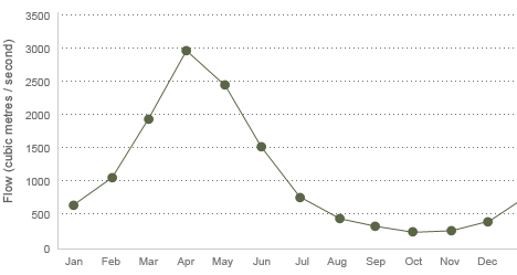
The Zambezi river, upstream from the falls, experiences a rainy season from late November to early April, and a dry season the rest of the year. The river's annual flood season is February to May with a peak in April, The spray from the falls typically rises to a height of over 400 metres (1,300 ft), and sometimes even twice as high, and is visible from up to 48 km (30 mi) away. At full moon, a "moonbow" can be seen in the spray instead of the usual daylight rainbow. During the flood season, however, it is impossible to see the foot of the falls and most of its face, and the walks along the cliff opposite it are in a constant shower and shrouded in mist. Close to the edge of the cliff, spray shoots upward like inverted rain, especially at Zambia's Knife-Edge Bridge.
As the dry season takes effect, the islets on the crest become wider and more numerous, and in September to January up to half of the rocky face of the falls may become dry and the bottom of the First Gorge can be seen along most of its length. At this time it becomes possible (though not necessarily safe) to walk across some stretches of the river at the crest. It is also possible to walk to the bottom of the First Gorge at the Zimbabwean side. The minimum flow, which occurs in November, is around a tenth of the April figure; this variation in flow is greater than that of other major falls, and causes Victoria Falls' annual average flow rate to be lower than might be expected based on the maximum flow.
Zambia's independence and Rhodesia's UDI
In 1964, Northern Rhodesia became the independent state of Zambia. The following year, Rhodesia unilaterally declared independence. This was not recognized by Zambia, the United Kingdom or the vast majority of states and led to UN-mandated sanctions. In response to the emerging crisis, in 1966 Zambia restricted or stopped border crossings; it did not re-open the border completely until 1980. Guerilla warfare arose on the southern side of the Zambezi from 1972: the Rhodesian Bush War. Visitor numbers began to drop, particularly on the Rhodesian side. The war affected Zambia through military incursions, causing the latter to impose security measures including the stationing of soldiers to restrict access to the gorges and some parts of the falls.
Zimbabwe's internationally recognised independence in 1980 brought comparative peace, and the 1980s witnessed renewed levels of tourism and the development of the region as a centre for adventure sports. Activities that gained popularity in the area include whitewater rafting in the gorges, bungee jumping from the bridge, game fishing, horse riding,kayaking, and flights over the falls.
Tourism in recent years:
By the end of the 1990s almost 300,000 people were visiting the falls annually, and this was expected to rise to over a million in the next decade. Unlike the game parks, Victoria Falls has more Zimbabwean and Zambian visitors than international tourists; the attraction is accessible by bus and train, and is therefore comparatively inexpensive to reach.
The two countries permit tourists to make day trips from each side and visas can be obtained at the border posts. Costs vary from US$50-US$90. Visitors with single entry visas will need to purchase a visa each time they cross the border. Regular changes in visa regulations mean visitors should check the rules before crossing the border.
A famous feature is the naturally formed Devil's Pool, near the edge of the falls on Livingstone Island on the Zambian side. When the river flow is at a certain level, usually between September and December, a rock barrier forms an eddy with minimal current, allowing adventurous swimmers to splash around in relative safety a few feet from the point where the water cascades over the falls.Occasional deaths have been reported when people have slipped over the rock barrier.
The numbers of visitors to the Zimbabwean side of the falls has historically been much higher than the number visiting the Zambia side, due to the greater development of the visitor facilities there. However, the number of tourists visiting Zimbabwe began to decline in the early 2000s as political tensions between supporters and opponents of president Robert Mugabe increased. In 2006, hotel occupancy on the Zimbabwean side hovered at around 30%, while the Zambian side was at near-capacity, with rates in top hotels reaching US$630 per night. The rapid development has prompted the United Nations to consider revoking the Falls' status as a World Heritage Site. In addition, problems of waste disposal and a lack of effective management of the falls' environment are a concern.
The naturally formed "Devil's Pool", where some tourists swim despite a small risk of plunging over the edge.
Two white rhinos at Mosi-oa-Tunya national park in May 2005. They are not indigenous, but were imported from South Africa.
National parks
The two national parks at the falls are relatively small—Mosi-oa-Tunya National Park is 66 square kilometres (16,309 acres) and Victoria Falls National Park is 23 square kilometres (5,683 acres). However, next to the latter on the southern bank is the Zambezi National Park, extending 40 kilometres (25 mi) west along the river. Animals can move between the two Zimbabwean parks and can also reachMatetsi Safari Area, Kazuma Pan National Park and Hwange National Park to the south. On the Zambian side, fences and the outskirts of Livingstone tend to confine most animals to the Mosi-oa-Tunya National Park. In addition fences put up by lodges in response to crime restrict animal movement. Although Zimbabwe has had recent economic difficulties, Victoria Falls town has always been somewhat removed and the people are as welcoming and friendly as ever. Tourism slowed down over the last 10 years but many hotels have taken this time to renovate and improve. In 2004 a separate group of police called the Tourism Police was started. They are commonly seen around the main tourist areas, and can be identified by their uniforms with yellow reflective bibs.
Vegetation
Mopane woodland savannah predominates in the area, with smaller areas of Miombo and Rhodesian Teak woodland and scrubland savannah. Riverine forest with palm trees lines the banks and islands above the falls. The most notable aspect of the area's vegetation though is the rainforest nurtured by the spray from the falls, containing plants rare for the area such as pod mahogany, ebony, ivory palm, wild date palm and a number of creepers and lianas. Vegetation has suffered in recent droughts, and so have the animals that depend on it, particularly antelope.
Wildlife
The national parks contain abundant wildlife including sizable populations of elephant, buffalo, giraffe, zebra, and a variety of antelope. Lion and leopard are only occasionally seen.Vervet monkeys and baboons are common. The river above the falls contains large populations of hippopotamus and crocodile. Elephants cross the river in the dry season at particular crossing points.
Klipspringers and clawless otters can be glimpsed in the gorges, but they are mainly known for 35 species of raptors. The Taita Falcon, Black Eagle, Peregrine Falcon and Augur Buzzard breed there. Above the falls, herons, Fish Eagles and numerous kinds of waterfowl are common.
Fish
The river is home to 39 species of fish below the falls and 89 species above it. This illustrates the effectiveness of the falls as a dividing barrier between the upper and lower Zambezi.
Natural environment:
The Victoria Falls Gorges
The whole volume of the Zambezi River pours through the First Gorge's 110-meter-wide (360 ft) exit for a distance of about 150 meters (500 ft), then enters a zigzagging series of gorges designated by the order in which the river reaches them. Water entering the Second Gorge makes a sharp right turn and has carved out a deep pool there called the Boiling Pot. Reached via a steep footpath from the Zambian side, it is about 150 metres (500 ft) across. Its surface is smooth at low water, but at high water is marked by enormous, slow swirls and heavy boiling turbulence. Objects—and humans—that are swept over the falls, including the occasional hippo or crocodile, are frequently found swirling about here or washed up at the north-east end of the Second Gorge. This is where the bodies of Mrs Moss and Mr Orchard, mutilated by crocodiles, were found in 1910 after two canoes were capsized by a hippo at Long Island above the falls.

The First Gorge - Above: Viewd from the Zambian side

History Since the 1900's


The whole volume of the Zambezi River pours through the First Gorge's 110-meter-wide (360 ft) exit for a distance of about 150 meters (500 ft), then enters a zigzagging series of gorges designated by the order in which the river reaches them. Water entering the Second Gorge makes a sharp right turn and has carved out a deep pool there called the Boiling Pot. Reached via a steep footpath from the Zambian side, it is about 150 metres (500 ft) across. Its surface is smooth at low water, but at high water is marked by enormous, slow swirls and heavy boiling turbulence. Objects—and humans—that are swept over the falls, including the occasional hippo or crocodile, are frequently found swirling about here or washed up at the north-east end of the Second Gorge. This is where the bodies of Mrs Moss and Mr Orchard, mutilated by crocodiles, were found in 1910 after two canoes were capsized by a hippo at Long Island above the falls.
Victoria Falls Entrance - Zimbabwe Side
Victoria Falls Flow
(Cubic Metres / Second)
|
|
||||||||||||||
|---|---|---|---|---|---|---|---|---|---|---|---|---|---|---|---|
|
|
|
||||||||||||||
|
|
|
||||||||||||||
|
Köppen Classification: Mid-Latitude Steppe and Desert Climate |
|
||||||||||||||
|
|
|
||||||||||||||
|
|
|
||||||||||||||
|
|
|